 This online data viewer provides user-friendly access to regional land cover and land cover change information developed through NOAA’s Coastal Change Analysis Program (C-CAP). The Land Cover Atlas eliminates the need for desktop geographic information system software, or advanced technical expertise, by processing C-CAP data for the user and providing easy access to that distilled information. The tool summarizes general change trends and can highlight specific changes of interest.
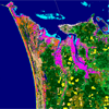
The data in this tool was derived through NOAA’s Coastal Change Analysis Program (C-CAP). C-CAP uses multiple dates of remotely sensed imagery to produce nationally standardized land cover and land change information for the coastal regions of the U.S. These products provide inventories of coastal intertidal areas, wetlands, and adjacent uplands. The goal is to monitor these habitats by updating the land cover maps every five years.
Click here to launch the C-CAP Atlas
Features
- Helps users to visually analyze and explore NOAA’s geospatial land cover data by county for areas of user interest
- Allows users to query specific types of land cover changes for specific date ranges and potentially evaluate their amount and location in relation to past management practices
- Creates summary reports and data tables to enhance communication and the decision-making process
Notes and Limitations
While efforts have been made to ensure that data are accurate and reliable within the limits of current technology, C-CAP data sets are not jurisdictional or intended for use in litigation. These data are intended for use in identifying regional landscape patterns and major functional habitats. C-CAP is a national and regional data set that should be used only as a screening tool for very local or site-specific management decisions. Small features and changes should be verified with a higher resolution data source.
For more information about the Coastal Change Analysis Program, and to access C-CAP data visit:
www.csc.noaa.gov/landcover/atlas