About the Harris Beach Rocky Shore Area
Description
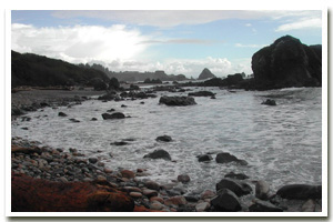
Approximately three miles of intertidal habitat and beaches from Harris Beach on the north to Chetco Point on the south, adjacent to the north end of the City of Brookings, in Curry County, Oregon. Goat Island is immediately offshore of Harris Beach State Park and is the largest of the numerous offshore rocks that front this section of coastline. In fact, Goat Island is the largest island offshore of Oregon! |
|
Designation
 Research Reserve and Marine Garden. The Harris Beach Marine Garden includes “all rocky areas, tide pools, and sand beaches situated between high tide and extreme low tide lying between a line projecting perpendicular to shore from the Harris Beach State Park beach access parking area on the north, and a line projecting perpendicular to shore from the road entrance to Harris Beach State Park off of Highway 101 on the north.” Also, the areas not within the Marine Garden but adjacent to it are part of the Brookings Research Reserve. Brookings Research Reserve includes the coastline “½ mile north of Harris Beach State Park on the north, and the mouth of the Chetco River on the south, except that portion of the area within the Harris Beach Marine Garden.” Goat Island and all offshore rocks are part of the Oregon Islands National Wildlife Refuge. Research Reserve and Marine Garden. The Harris Beach Marine Garden includes “all rocky areas, tide pools, and sand beaches situated between high tide and extreme low tide lying between a line projecting perpendicular to shore from the Harris Beach State Park beach access parking area on the north, and a line projecting perpendicular to shore from the road entrance to Harris Beach State Park off of Highway 101 on the north.” Also, the areas not within the Marine Garden but adjacent to it are part of the Brookings Research Reserve. Brookings Research Reserve includes the coastline “½ mile north of Harris Beach State Park on the north, and the mouth of the Chetco River on the south, except that portion of the area within the Harris Beach Marine Garden.” Goat Island and all offshore rocks are part of the Oregon Islands National Wildlife Refuge. |
| |
|
|
Key Resources
Easily accessible intertidal habitat; nearshore kelp beds and subtidal habitat with Goat Island just offshore which is home to harbor seals and seabirds (one of the largest nesting sites in the state). |
|
What can you do here?
Relatively high use from adjacent state park; uses include educational activities, tidepooling, sightseeing, beachcombing, picnicking, photography and sport fishing from shore. Harris Beach State Park provides interpretive services on site including tidepool naturalist walks and campground programs. ODFW regulations for Harris Beach as a Marine Garden mean it is closed to the collection of all shellfish and marine invertebrates. To the south and north of the park, intertidal collection is limited to certain species within the Brookings Research Reserve (see ODFW fishing regulations for details), except by scientific collection permit. |
Educational Opportunities
Harris Beach State Park rangers offers both tidepool interpretive walks and campground programs that focus on rocky shore topics. There are several interpretive panels at the site including posted “Marine Garden” signs at all three of the main access trails and the ODFW, “Welcome to Our Home” rocky shore panels. USFWS plans to place one of the new offshore rocks/bird panels in the near future educating the public about regulations and the reasons behind them. In several locations there are pay-per use ($0.50) viewing scopes, which afford visual access to the rocky shore and offshore rocks (i.e., Goat Island).
Getting to the Rocky shore at Harris Beach
Primary access is from well-marked, easy trails from Harris Beach State Park. There are several improved and easy access trails from Harris Beach State Park, the entrance to which is on the north end of the city of Brookings, Oregon off Highway 101. Following the main park road to its end, which loops around at the day-use parking area affords the easiest access to the far north end of the site). From the day-use area, it is a short walk to the beach on an improved trail. Approximately 0.2 miles south of the day use area, there is another improved (paved) path that leads off the main park road and down to shore level, north of the entrance to the campground. On the far south end of the site, a path leads down from the main road (near the entrance to the park) to shore level. An improved (wood-chip covered) trail runs almost the entire length of the upland park from the entrance to just before the day-use area with another trail running to the campground in the middle. Access to Goat Island and all offshore rocks is prohibited as they are part of the Oregon Islands NWR and are important habitat for birds and marine mammals.
 Public Access Option 1 for Harris Beach Rocky Shore Public Access Option 1 for Harris Beach Rocky Shore
Public Access Option 2 for Harris Beach Rocky Shore
Who Owns this Site?
Submerged and submersible (intertidal) lands: Division of State Lands; offshore rocks above Mean High Water: US Fish and Wildlife Service; adjacent beaches and much of the adjacent upland: Oregon Park and Recreation Department. The remainder of the uplands to the north and south of Harris Beach State Park is privately owned. |
|
Who Manages this Site?
   Oregon Parks and Recreation Department manages the ocean shore recreation area. This particular site is managed by Oregon Department of Fish and Wildlife (ODFW) as a Marine Garden (fronting the park) and Research Reserve. Much of the upland is managed as Harris Beach State Park, which is part of OPRD Area 4 (South-Western Oregon) and the Harris Beach Management Unit. Offshore rocks are managed by USFWS as part of the Oregon Islands National Wildlife Refuge. Oregon Parks and Recreation Department manages the ocean shore recreation area. This particular site is managed by Oregon Department of Fish and Wildlife (ODFW) as a Marine Garden (fronting the park) and Research Reserve. Much of the upland is managed as Harris Beach State Park, which is part of OPRD Area 4 (South-Western Oregon) and the Harris Beach Management Unit. Offshore rocks are managed by USFWS as part of the Oregon Islands National Wildlife Refuge. |
|
Data for the Harris Beach Rocky Shore
[6 Records Listed]
Harris Beach Rocky Shore GIS Data |
Data Layer |
Source |
Scale |
Year |
Download |
|
OCMP |
10,000 |
1928 |
|
|
USGS |
24,000 |
1994 |
|
|
USGS |
24,000 |
1986 |
|
|
ODFW |
100,000 |
2008 |
|
|
ODFW |
100,000 |
2008 |
|
|
ODOT |
6,000 |
1967 |
|
[6 Records Listed]
Information compiled by Laurel Hillmann, NOAA Coastal Management Fellow, OPRD |