Description
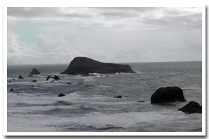
1.6 miles of intertidal habitat located approximately 1 ½ miles north of Brookings, in Curry County, Oregon. |
|
Designation
The beaches and rocky shores of Oregon are part of Oregon’s Ocean Shore Recreation Area and the offshore rocks and islands are part of the Oregon Islands National Wildlife Refuge. |
| |
|
|
Key Resources
Rich and diverse intertidal habitat. |
|
What can you do here?
Activities include sightseeing, beachcombing, tidepooling, bird watching, and sport fishing. Lone Ranch Beach has a large parking lot and day-use facilities and receives heavy use from local residents and tourists traveling along Highway 101. |
Educational Opportunities
There is an interpretive panel at the Lone Ranch Beach day-use parking area that describes the history of the area, including traditional Native American use and the Borax mining company history.
Getting to the Rocky shore at South Sam Boardman - Rainbow Rock
Access is a short walk along Lone Ranch Beach starting from Lone Ranch State Wayside. The Lone Ranch State Wayside is the southern most Oregon State Parks facility within the Samuel Boardman Scenic Corridor and can be found off highway 101, approximately 1½ mile north of the city of Brookings. From the parking area, there is a short paved trail down to the beach. From the beach, walking south along the beach for approximately 0.34 miles affords access the rocky shore.
Who Owns this Site?
Submerged and submersible (intertidal) lands: Division of State Lands; offshore rocks above Mean High Water: US Fish and Wildlife Service; adjacent beaches and upland: Oregon Parks and Recreation Department. |
|
Who Manages this Site?
  Oregon Parks and Recreation Department manages the ocean shore recreation area. This site is within Sam Boardman State Scenic Corridor, which is part of OPRD Area 4 (South-Western Oregon) and the Harris Beach Management Unit. Offshore rocks are managed by USFWS as part of the Oregon Islands National Wildlife Refuge. Oregon Parks and Recreation Department manages the ocean shore recreation area. This site is within Sam Boardman State Scenic Corridor, which is part of OPRD Area 4 (South-Western Oregon) and the Harris Beach Management Unit. Offshore rocks are managed by USFWS as part of the Oregon Islands National Wildlife Refuge. |
|