
Tools for Coastal Management
Tools help users accomplish common tasks. In the case of Coastal Atlas tools we've assembled links to a variety of tools designed to help different types of coastal users answer questions that are common in coastal areas. In addition, we are constructing a series of Oregon topic-specific coastal tools. These include tools for beach access and water quality information, as well as shoreline photo viewing tools.
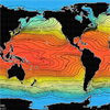 The World Ocean Atlas is a set of objectively analyzed (1° grid) climatological fields of in situ temperature, salinity, dissolved oxygen, Apparent Oxygen Utilization (AOU), percent oxygen saturation, phosphate, silicate, and nitrate at standard depth levels for annual, seasonal, and monthly compositing periods for the World Ocean. It also includes associated statistical fields of observed oceanographic profile data interpolated to standard depth levels on both 1° and 5° grids
 Giovanni is a Web-based application developed by the Goddard Earth Sciences Data and Information Services Center that provides a simple and intuitive way to visualize, analyze, and access vast amounts of Earth science remote sensing data without having to download the data. Giovanni is an acronym for the Goddard Earth Sciences Data and Information Services Center Interactive Online Visualization ANd aNalysis Infrastructure.
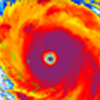
 The Physical Oceanography Distributed Active Archive Center (PO.DAAC) is the NASA data center responsible for archiving and distributing data relevant to the physical state of the ocean. The PO.DAAC Ocean ESIP Tool (POET) provides interactive, on-line subsetting and visualization of many of PO.DAAC's data products. Viewing options include: latitude-longitude maps, animations, time series plots, and space-time profiles.
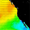 The Climatology of Global Ocean Winds (COGOW), is a web-based interactive atlas from which users can retrieve climatological wind maps as well as wind statistics, both in tabular and graphic form, on a 0.5° latitude by 0.5° latitude grid, for almost any particular region of interest. The accuracy of QuikSCAT wind measurements is equivalent to that of observations by well-calibrated buoys.
 VDatum is a tool developed by the Office of Coast Survey for the transformation of elevation data from one vertical datum into another. Such transformations are necessary when data from diverse sources are to be combined or compared. Artificial steps or discontinuties can appear in maps and charts if they are built from data based on inconsistent datums. This problem can be particularly acute in coastal areas.
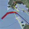 The Topographic and Bathymetric Data Inventory displays the best-available topographic and bathymetric data for the United States. It includes information from two inventories, one conducted by the NOAA Coastal Services Center and one by the Federal Emergency Management Agency (FEMA).