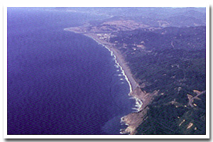
Here identified as the Rogue littoral cell, this sandy 11 mile segment of Oregon's coastal shoreline extends from mileage Hubbard Mound/Otter Point to Cape Sebastian. It is associated with the Rogue river mouth(s) and accompanying Rogue River Estuary.
The Rogue sandy shore lies within Curry County and makes up the shoreline fronting the communities of Gold Beach. It consists of Bluff Backed shoreline. Of this shoreline approximately 52.7% is urban and 17.3% is park. An unknown percentage of this stretch of sandy shoreline is hardened with shore protection structures. Predominant land uses include those typical of urban,ruralsettings.
Chronic coastal hazards for the Rogue sandy shore include landsliding and sloughing. Catastrophic hazards include earthquakes, and the groundshaking, subsidence, landsliding, liquefaction, and tsunami that accompany them.
Key recreational facilities and cultural features include: Buena Vista Ocean State Park, Cape Sebastian State Park and . |