About the Nehalem River Estuary
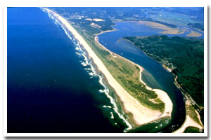
The Nehalem River estuary is located on the Oregon coast at Nehalem. The estuary is approximately 2749 acres in area and has a watershed of approximately 855 square miles.
The Nehalem River estuary is designated as a Shallow Draft Development estuary under the Oregon Estuary Classification system. The geomorphology of the area is that of a Drowned River Mouth estuary.
The Nehalem River estuary is located in Tillamook County. The principle industries of Tillamook County are agriculture, lumber, fishing, and recreation. Dairy farms dominate the county's fertile valleys providing milk for the well-known Tillamook cheese. Logging and lumbering are becoming a significant economic force again due to the reforestation of most of the 'Tillamook Burn' area. With seventy-five miles of coastline, four bays, and nine rivers, recreational and tourist facilities are numerous. The 1997 population of Tillamook County of 23,800 represented an increase of 10.3% since 1990.
Kayaking and birdwatching are popular on the sheltered, forest-rimmed Nehalem Bay estuary. Nehalem Bay State Park has a boat ramp, but the most popular put-in is beside Hwy. 101, just across the Nehalem River bridge from the quaint old town of Nehalem. On a sandy peninsula, this park has a campground, a separate equestrian camp with corrals and horse trails, an airstrip, a 1.5-mile paved bike loop, and lots of room for beach explorations on foot. |
Data for the Nehalem River Estuary
[26 Records Listed]
Nehalem River Estuary GIS Data |
Data Layer |
Source |
Scale |
Year |
Download |
|
OCMP |
1,000 |
1979 |
|
|
OCMP |
1,000 |
1979 |
|
|
OCMP |
1,000 |
1986 |
|
|
OCMP |
1,000 |
1986 |
|
|
OCMP |
1,000 |
1986 |
|
|
NOAA |
20,000 |
1990 |
|
|
OCMP |
5,000 |
1954 |
|
|
OCMP |
5,000 |
1954 |
|
|
OCMP |
5,000 |
1954 |
|
|
OCMP |
5,000 |
1954 |
|
|
OCMP |
5,000 |
1954 |
|
|
USGS |
24,000 |
1994 |
|
|
USGS |
24,000 |
1994 |
|
|
USGS |
24,000 |
1994 |
|
|
USGS |
24,000 |
1994 |
|
|
USGS |
24,000 |
1985 |
|
|
USGS |
24,000 |
1985 |
|
|
USGS |
24,000 |
1985 |
|
|
USGS |
24,000 |
1985 |
|
|
DOGAMI |
24,000 |
2004 |
|
|
ODOT |
6,000 |
1967 |
|
|
OCMP |
0.25 m |
2005 |
|
|
OCMP |
50,000 |
2014 |
|
|
OCMP |
50,000 |
2014 |
|
|
OCMP |
50,000 |
2014 |
|
|
OCMP |
50,000 |
2014 |
|
[26 Records Listed]
Information provided by the Oregon Coastal Management Program |