About the Chetco Point Rocky Shore Area
Description
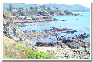
Approximately one mile of rocky shoreline between Chetco Point and the mouth of the Chetco River, fronting the city of Brookings, in Curry County, Oregon. |
|
Designation
 Brookings Research Reserve. Brookings Research Reserve includes the coastline “½ mile north of Harris Beach State Park on the north, and the mouth of the Chetco River on the south, except that portion of the area within the Harris Beach Marine Garden.” Brookings Research Reserve. Brookings Research Reserve includes the coastline “½ mile north of Harris Beach State Park on the north, and the mouth of the Chetco River on the south, except that portion of the area within the Harris Beach Marine Garden.” |
| |
|
|
Key Resources
Intertidal and subtidal habitat, including kelp beds with some use of the offshore rocks by seabirds. |
|
What can you do here?
Some of the typical types of human use within this site include beachcombing, tidepooling, fishing near the Chetco River Jetty and SCUBA diving (offshore). Designation as an intertidal research reserve means that intertidal collection is limited to certain species (see ODFW fishing regulations for details), except by scientific collection permit. |
Getting to the Rocky shore at Chetco Point
Access is afforded from Chetco Point Park, which is located by following Wharf Street to its end off of US HWY 101 in Brookings, Oregon.
 Public Access Option 1 for Chetco Point Rocky Shore Public Access Option 1 for Chetco Point Rocky Shore
Public Access Option 2 for Chetco Point Rocky Shore
Who Owns this Site?
Submerged and submersible (intertidal) lands: Division of State Lands; offshore rocks above Mean High Water: US Fish and Wildlife Service. The majority of the uplands within this section of coastline are privately owned, except for an approximately nine-acre parcel, owned and managed by the City of Brookings as Chetco Point Park. |
|
Who Manages this Site?
 Oregon Parks and Recreation Department manages the ocean shore recreation area. This particular section of the coast is managed by Oregon Department of Fish and Wildlife (ODFW) as a Research Reserve. Chetco Point is managed as a local park by the City of Brookings. Oregon Parks and Recreation Department manages the ocean shore recreation area. This particular section of the coast is managed by Oregon Department of Fish and Wildlife (ODFW) as a Research Reserve. Chetco Point is managed as a local park by the City of Brookings. |
|
Data for the Chetco Point Rocky Shore
[1 Records Listed]
Chetco Point Rocky Shore GIS Data |
Data Layer |
Source |
Scale |
Year |
Download |
|
ODFW |
100,000 |
2008 |
|
[1 Records Listed]
Information compiled by Laurel Hillmann, NOAA Coastal Management Fellow, OPRD |