About the Cape Perpetua Rocky Shore Area
Description
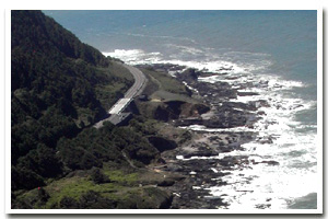
1.3 miles of intertidal habitat between the north side of Devil’s Churn on the north and the northerly boundary of Neptune State Park on the south in Lincoln County approximately two miles south of Yachats, Oregon. |
|
Designation
 Marine Garden. The marine garden area encompasses “all rocky areas, tide pools, and sand beaches situated between extreme high tide and extreme low tide lying between the north side of Devil’s Churn on the north and the northerly boundary of Neptune State Park on the south.” Marine Garden. The marine garden area encompasses “all rocky areas, tide pools, and sand beaches situated between extreme high tide and extreme low tide lying between the north side of Devil’s Churn on the north and the northerly boundary of Neptune State Park on the south.” |
| |
|
|
Key Resources
Publicly accessible intertidal habitat, including mature mussel beds with some use of the cliffs to the north by seabirds. |
|
What can you do here?
Cape Perpetua's status as an intertidal marine garden means that all collection of shellfish and other marine invertebrates is prohibited. Exceptions are that single mussels may be taken for bait and razor clams may be collected at Cape Perpetua. See ODFW marine zone fishing regulations for details. Visitor use of the area is relatively high and includes tidepooling, sightseeing, and sport fishing from shore. School groups use Cape Perpetua as an outdoor educational resource. |
Educational Opportunities
The USDA Forest Service visitor’s center in the Cape Perpetua Scenic Area offers seasonal ranger led tidepool walks to interested school and other groups (call ahead to arrange a walk). If a low tide coincides with the twice-daily scheduled interpretive walks, the Forest Service interpretive rangers will lead a walk down to the tidepools, otherwise they have a walk through the upland forest. If there are enough interested people at other times of the day (with a good low tide) the rangers will lead impromptu walks to the tidepools from the visitors center. The center’s naturalists will also do in-class presentations for local schools and they have a PowerPoint presentation that they will give at the center if enough people are interested. They have videos, which they show on request (including one entitled “Cape Perpetua Discovery at the Edge”). The movie provides basic geological history of Oregon, general Oceanography (waves, tides), Marine Biology, tidepool etiquette, cultural information, and the take home message of discovery without damage. It also has some very good underwater footage of sea life. There is interpretive signage down by the rocky shore including posters titled “The Intertidal Zone”, “Rocky Depressions”, and “Shell Middens.”
Getting to the Rocky shore at Cape Perpetua
Several well-developed access trails in Cape Perpetua Scenic Area, including one from the visitor center, and from Devils’ Churn Wayside with visual access from Cooks Chasm viewpoint.
 Public Access Option 1 for Cape Perpetua Rocky Shore Public Access Option 1 for Cape Perpetua Rocky Shore
 Public Access Option 2 for Cape Perpetua Rocky Shore Public Access Option 2 for Cape Perpetua Rocky Shore
Public Access Option 3 for Cape Perpetua Rocky Shore
Who Owns this Site?
Submerged and submersible (intertidal) lands: Division of State Lands; beach areas: Oregon Department of Parks and Recreation; upland: U.S. Forest Service. |
|
Who Manages this Site?
  Designated by ODFW as Marine Garden (intertidal area); Cape Perpetua Visitor’s Center (U.S. Forest Service) provides information and interpretive services. Designated by ODFW as Marine Garden (intertidal area); Cape Perpetua Visitor’s Center (U.S. Forest Service) provides information and interpretive services. |
|
Data for the Cape Perpetua Rocky Shore
[9 Records Listed]
Cape Perpetua Rocky Shore GIS Data |
Data Layer |
Source |
Scale |
Year |
Download |
|
USGS |
24,000 |
1994 |
|
|
USGS |
24,000 |
1985 |
|
|
ODFW |
100,000 |
2008 |
|
|
ODOT |
6,000 |
1967 |
|
|
ODFW |
24,000 |
2010 |
|
|
ODFW |
24,000 |
2010 |
|
|
ODFW |
24,000 |
2010 |
|
|
ODFW |
24,000 |
2010 |
|
|
ODFW |
24,000 |
2010 |
|
[9 Records Listed]
Information compiled by Laurel Hillmann, NOAA Coastal Management Fellow, OPRD |