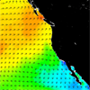
 The Climatology of Global Ocean Winds (COGOW), is a web-based interactive atlas from which users can retrieve climatological wind maps as well as wind statistics, both in tabular and graphic form, on a 0.5° latitude by 0.5° latitude grid, for almost any particular region of interest. The accuracy of QuikSCAT wind measurements is equivalent to that of observations by well-calibrated buoys.
These wind statistics are based on ten years (August 1999 – November, 2009) of QuikSCAT measurements. The global coverage of these QuikSCAT data provides valuable information about the wind statistics in the many regions of the world ocean that are sparsely sampled by ships and buoys.
Wind roses summarize the occurrence of overlapping 3-day average winds within a 0.5° latitude by 0.5° longitude bin centered at any location chosen on the grid of points, showing their strength, direction and relative frequency. The wind rose is interpreted as follows: the length of the barbs that extend radially from the center of the rose, reflect each direction's relative frequency. In each direction, the barb’s appearance varies through several styles in sequence. More information on how to read a wind rose can be found in the COGOW user manual, available from the website.
Click Here to go to site: http://numbat.coas.oregonstate.edu/cogow/