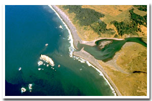
About the Sixes River Estuary
The Sixes River estuary is located on the Oregon coast at Sixes. The estuary is approximately 330 acres in area and has a watershed of approximately 129 square miles.
The Sixes River estuary is designated as a Natural estuary under the Oregon Estuary Classification system. The geomorphology of the area is that of a Blind estuary.
The Sixes River estuary is located in Curry County. The formerly mining centered economy of Curry County has largely reoriented to agriculture and timber. Port Orford cedar (Lawson Cypress) and myrtlewood are important export products. Port districts were established at Port Orford in 1919 and Gold Beach in 1955. The county has excellent grazing areas for raising cattle and sheep. The county also produces blueberries, horticultural nursery stock, and ninety percent of all Easter lilies raised in the United States. Vacation and recreational possibilities in the county draw tourists to the area and provide additional economic diversity. The first county census in 1860 showed a population of 393 in Curry County. There has been a steady increase in population with the 1997 population given at 22,200, a 14.9% increase over 1990.
Just south of the Sixes River Estuary, Cape Blanco's plateau juts more than a mile to sea. The historic day-use area there includes a lighthouse and sweeping views, with a nearby state park campground. The Oregon Coast Trail provides hiking opportunities, and sea birds and a variety of migratory birds stop by the prominent headland. |
Data for the Sixes River Estuary
[36 Records Listed]
Sixes River Estuary GIS Data |
Data Layer |
Source |
Scale |
Year |
Download |
|
USGS |
24,000 |
1994 |
|
|
USGS |
24,000 |
1999 |
|
|
ODFW |
24,000 |
2003 |
|
|
ODFW |
24,000 |
2003 |
|
|
REO |
24,000 |
2002 |
|
|
REO |
24,000 |
2002 |
|
|
PSMFC |
100,000 |
2001 |
|
|
Ecotrust |
3,000,000 |
1985 |
|
|
ODFW |
100,000 |
2002 |
|
|
OSUCLAMS |
24,000 |
2000 |
|
|
USGS |
2,000,000 |
1980 |
|
|
ODF |
24,000 |
2000 |
|
|
USGS |
24,000 |
1996 |
|
|
ODFW |
100,000 |
1997 |
|
|
ONHP |
100,000 |
1851-1909 |
|
|
OWRD |
100,000 |
2001 |
|
|
USFS |
126,720 |
1993 |
|
|
FEMAT |
100,000 |
1994 |
|
|
FEMAT |
24,000 |
1993 |
|
|
FEMAT |
100,000 |
1993 |
|
|
BLM |
24,000 |
2002 |
|
|
FEMAT |
126,720 |
1993 |
|
|
USGS |
100,000 |
1990 |
|
|
EPA |
100,000 |
1996 |
|
|
ODOT |
24,000 |
2003 |
|
|
ODFW |
100,000 |
1996 |
|
|
OWRD |
24,000 |
1998 |
|
|
ODFW |
100,000 |
2002 |
|
|
ONHP |
250,000 |
2003 |
|
|
USGS |
500,000 |
1996 |
|
|
USGS |
2,000,000 |
1997 |
|
|
OCMP |
0.25 m |
2005 |
|
|
OCMP |
50,000 |
2014 |
|
|
OCMP |
50,000 |
2014 |
|
|
OCMP |
50,000 |
2014 |
|
|
OCMP |
50,000 |
2014 |
|
[36 Records Listed]
Information provided by the Oregon Coastal Management Program |