About the North Boardman & Hooskanaden Creek Rocky Shore Area
Description
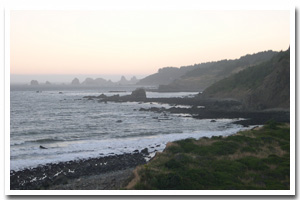
Approximately one mile of intertidal habitat (from just south of Burnt Hill Creek Cove to just south of Hooskanaden Creek) located approximately 14 miles south of Gold Beach in Curry County, Oregon. |
|
Designation
The beaches and rocky shores of Oregon are part of Oregon’s Ocean Shore Recreation Area and the offshore rocks and islands are part of the Oregon Islands National Wildlife Refuge. |
| |
|
|
Key Resources
Productive and diverse intertidal and subtidal habitat (including kelp beds) and several small seabird nesting colonies. |
|
What can you do here?
Relatively low level of use due to remote location and lack of well-marked access and parking. Uses include hiking, beachcombing, scientific research, tidepooling, seaweed harvest and sport fishing from shore. |
Getting to the Rocky shore at North Boardman & Hooskanaden Creek
Trails from small turnouts off Highway 101. Just south of Burnt Hill Creek there is a small turnout with a primitive (and undeveloped) but relatively easy trail down to shore level. Access to the south of the site is possible via a small Highway 101 turnoff, immediately after the sign indicating the beginning of Samuel Boardman State Scenic Corridor. From the turn-off there is an old road that is now blocked off and grown over, that leads down to the cobble beach (approximately 450 ft) with the rocky shore site to the north. From the end of the trail, it is approximately 0.3 miles to the beginning of the south end of the site. The Oregon Coast Trail fronts the coastline for approximately 0.26 miles in this area before returning to the highway. Instead of walking along the rocky shore (which can be difficult), it is possible to join the trail near the start of the same old road and access the site slightly further north.
 Public Access Option 1 for North Boardman & Hooskanaden Creek Rocky Shore Public Access Option 1 for North Boardman & Hooskanaden Creek Rocky Shore
Who Owns this Site?
Submerged and submersible (intertidal) lands: Division of State Lands; adjacent beaches and upland: Oregon Parks and Recreation Department (as part of Samuel Boardman State Scenic Corridor). |
|
Who Manages this Site?
  This site is within Sam Boardman State Scenic Corridor, which is part of OPRD Area 4 (South-Western Oregon) and the Harris Beach Management Unit. This site is within Sam Boardman State Scenic Corridor, which is part of OPRD Area 4 (South-Western Oregon) and the Harris Beach Management Unit. |
|
Data for the North Boardman & Hooskanaden Creek Rocky Shore
[0 Records Listed]
North Boardman & Hooskanaden Creek Rocky Shore GIS Data |
Data Layer |
Source |
Scale |
Year |
Download |
|
|
|
|
|
[0 Records Listed]
Information compiled by Laurel Hillmann, NOAA Coastal Management Fellow, OPRD |