About the South Cove Cape Arago Rocky Shore Area
Description
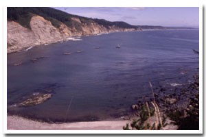
0.42 miles of intertidal habitat just south of the tip of Cape Arago, approximately 12 miles south of Coos Bay, in Coos County, Oregon. |
|
Designation
 Research Reserve. The south cove of Cape Arago is part of the Cape Arago headland research reserve. This site is part of “Area C” which is “all rocky areas, tide pools, and sand beaches situated between extreme high tide and extreme low tide lying between Simpson Reef overlook and a point ¾ of a mile south of Cape Arago State Park.” The area is also part of the Cape Arago headland “intertidal marine protected area” which is a designation meant for public awareness purposes only and does not hold any additional restrictions or regulations. Research Reserve. The south cove of Cape Arago is part of the Cape Arago headland research reserve. This site is part of “Area C” which is “all rocky areas, tide pools, and sand beaches situated between extreme high tide and extreme low tide lying between Simpson Reef overlook and a point ¾ of a mile south of Cape Arago State Park.” The area is also part of the Cape Arago headland “intertidal marine protected area” which is a designation meant for public awareness purposes only and does not hold any additional restrictions or regulations. |
| |
|
|
Key Resources
Rich, diverse, accessible intertidal habitat; scenic views to the south. Harbor seals use rocks in the area as a haulout. |
|
What can you do here?
Relatively high level of use including educational activities, tidepooling, sightseeing, surfing, kayaking and sport fishing from shore. |
Educational Opportunities
The site does not have any fixed interpretive displays, except for the marine protected area sign. The OPRD seasonal rocky shore interpreter uses the site to give regular tidepool walks, which are complemented by campground programs that focus on intertidal/marine life.
Getting to the Rocky shore at South Cove Cape Arago
Steep but improved trail from Cape Arago State Park. The trail is accessible from the south end of the Cape Arago State Park loop (right before the road loops around). There are only a few parking spots immediately adjacent to the trailhead but it is only a short walk from the main parking area at Cape Arago State Park, which has many spots.
 Public Access Option 1 for South Cove Cape Arago Rocky Shore Public Access Option 1 for South Cove Cape Arago Rocky Shore
Who Owns this Site?
Submerged and submersible (intertidal) lands: Division of State Lands; adjacent upland: Oregon Department of Parks and Recreation. |
|
Who Manages this Site?
  The intertidal area is currently managed as a research reserve area by the ODFW; the uplands are managed as Cape Arago State Park. Oregon Parks and Recreation Department manages the ocean shore recreation area. The intertidal area is currently managed as a research reserve area by the ODFW; the uplands are managed as Cape Arago State Park. Oregon Parks and Recreation Department manages the ocean shore recreation area. |
|
Data for the South Cove Cape Arago Rocky Shore
[1 Records Listed]
South Cove Cape Arago Rocky Shore GIS Data |
Data Layer |
Source |
Scale |
Year |
Download |
|
ODOT |
6,000 |
1967 |
|
[1 Records Listed]
Information compiled by Laurel Hillmann, NOAA Coastal Management Fellow, OPRD |