About the Indian Sands Rocky Shore Area
Description
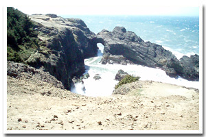
Approximately one mile of rocky coastline (from just north of Whaleshead Rock to just south of Thomas Creek) located approximately 10 miles north of Brookings in Curry County, Oregon. This section of coast is visually stunning and offers several viewpoints to enjoy amazing visual access but there is little physical access to the shoreline below the steep cliffs. |
|
Designation
The beaches and rocky shores of Oregon are part of Oregon's Ocean Shore Recreation Area and the offshore rocks and islands are part of the Oregon Islands National Wildlife Refuge. |
| |
|
|
Key Resources
Inaccessible intertidal and subtidal habitat including limited kelp beds and some seabird use of the associated nearshore rocks. |
|
What can you do here?
The majority of human use along this section of coastline is confined to upland uses such as hiking the Oregon Coast trail, sightseeing, and birdwatching. |
Getting to the Rocky shore at Indian Sands
There are no maintained trails that lead all the way to the beach along this section of the coast, however, visual access is amazing. Parking is available at the Indian Sands pulloff within Samuel Boardman State Park.
 Public Access Option 3 for Indian Sands Rocky Shore Public Access Option 3 for Indian Sands Rocky Shore
Who Owns this Site?
Submerged and submersible (intertidal) lands: Division of State Lands; adjacent beaches and upland: Oregon Parks and Recreation Department (as part of Samuel Boardman State Scenic Corridor). |
|
Who Manages this Site?
 Oregon Parks and Recreation Department manages the ocean shore recreation area. Samuel Boardman State Scenic Corridor is part of OPRD Area 4 and the Harris Beach management unit. Oregon Parks and Recreation Department manages the ocean shore recreation area. Samuel Boardman State Scenic Corridor is part of OPRD Area 4 and the Harris Beach management unit. |
|
Data for the Indian Sands Rocky Shore
[3 Records Listed]
Indian Sands Rocky Shore GIS Data |
Data Layer |
Source |
Scale |
Year |
Download |
|
USGS |
24,000 |
1994 |
|
|
USGS |
24,000 |
1986 |
|
|
ODOT |
6,000 |
1967 |
|
[3 Records Listed]
Information compiled by Laurel Hillmann, NOAA Coastal Management Fellow, OPRD |