About the Otter Point Rocky Shore Area
Description
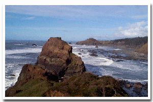
4.1 miles of cliffs and rocky intertidal habitat located just north of the Rogue River and the city of Gold Beach off the Old Coast Highway in Curry County, Oregon. |
|
Designation
The beaches and rocky shores of Oregon are part of Oregon’s Ocean Shore Recreation Area and the offshore rocks and islands are part of the Oregon Islands National Wildlife Refuge. |
| |
|
|
Key Resources
Extensive rocky intertidal habitat; six seabird colony sites. |
|
What can you do here?
Uses include picnicking, beachcombing, tidepooling, agate collecting, sport fishing, bird watching and whale watching. Rocky intertidal areas at each site receive low to moderate human use, primarily by local residents. Use of Otter Point State Recreation Site is currently low. Beach access to areas near Hubbard Mound and Nesika Beach is limited by private land ownership. |
Getting to the Rocky shore at Otter Point
Access to the Otter Point and the beach to the north is from the Otter Point State Recreation Area. Otter Point State Recreation Area is accessed by turning off HWY 101 onto the “Old Coast Road” and following it until the SRA sign, along a short road to a small day-use area/overlook Most of the area to the north is private and has restricted access. To access the north end rocky area, follow the path (approximately 0.1 mi) that leads towards the point and opens up to a grassy knoll. From there it is possible to reach shore level by using difficult unofficial trails that lead down from the grassy knoll. To access the south end rocky area, follow the main path from the cluster board to where it almost immediately branches to the left. The trail winds through the forest, across a bridged stream to Bailey Beach and across the beach (approximately .09 miles) to the south side of Otter Point.
 Public Access Option 1 for Otter Point Rocky Shore Public Access Option 1 for Otter Point Rocky Shore
Public Access Option 2 for Otter Point Rocky Shore
Who Owns this Site?
Submerged and submersible (intertidal) lands: Division of State Lands; several small offshore rocks above Mean High Water: U.S. Fish and Wildlife Service; dry sands beach areas and adjacent uplands at Otter Point: Oregon Department of Parks and Recreation; other adjacent uplands: private ownership. |
|
Who Manages this Site?
  Portions of the adjacent uplands are managed as Otter Rock State Recreation Site, which is part of OPRD Area 4 (South-Western Oregon), and the Cape Blanco Management Unit. Oregon Parks and Recreation Department manages the ocean shore recreation area. Offshore rocks are managed by USFWS as part of the Oregon Islands National Wildlife Refuge. Portions of the adjacent uplands are managed as Otter Rock State Recreation Site, which is part of OPRD Area 4 (South-Western Oregon), and the Cape Blanco Management Unit. Oregon Parks and Recreation Department manages the ocean shore recreation area. Offshore rocks are managed by USFWS as part of the Oregon Islands National Wildlife Refuge. |
|
Data for the Otter Point Rocky Shore
[1 Records Listed]
Otter Point Rocky Shore GIS Data |
Data Layer |
Source |
Scale |
Year |
Download |
|
ODOT |
6,000 |
1967 |
|
[1 Records Listed]
Information compiled by Laurel Hillmann, NOAA Coastal Management Fellow, OPRD |