About the Sea Lion Point Rocky Shore Area
Description
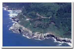
Sea Lion Point is located approximately 11 miles north of Florence in Lane County, Oregon. The most prominent feature along this section of coast is Sea Lion Cave, which is home to a threatened marine species, the Stellar sea lion. |
|
Designation
The beaches and rocky shores of Oregon are part of Oregon’s Ocean Shore Recreation Area and the offshore rocks and islands are part of the Oregon Islands National Wildlife Refuge. |
| |
|
|
Key Resources
Marine mammal (threatened Stellar sea lions and California sea lions) haulout and rookery areas and several colonies of seabirds on associated rocks and cliffs. |
|
What can you do here?
Typical uses along this section of coastline include marine mammal viewing, sightseeing and photography. For info on responsible marine wildlife viewing see this PDF. |
Educational Opportunities
Sea Lion Caves offers a variety of on-site interpretive services.
Getting to the Rocky shore at Sea Lion Point
There is no access to shore level in this section of the coast, however, visual access to Sea Lion Caves is afforded by paying an admission fee and taking an elevator down to a viewing area.
 Public Access Option 1 for Sea Lion Point Rocky Shore Public Access Option 1 for Sea Lion Point Rocky Shore
Public Access Option 2 for Sea Lion Point Rocky Shore
Who Owns this Site?
Submerged and submersible (intertidal) lands: Division of State Lands; rocks above MHW not connected to land at high tide: US Fish and Wildlife Service with the upland within this area under private ownership. |
|
Who Manages this Site?
 The beaches and rocky shores of Oregon are part of Oregon’s Ocean Shore Recreation Area, which is managed by Oregon Parks and Recreation Department. The National Oceanic and Atmospheric Administration (NOAA) is responsible for the management of sea lions and the US Fish and Wildlife Service (USFWS) is the agency in charge of migratory birds such as the seabirds that use this section of coast. The beaches and rocky shores of Oregon are part of Oregon’s Ocean Shore Recreation Area, which is managed by Oregon Parks and Recreation Department. The National Oceanic and Atmospheric Administration (NOAA) is responsible for the management of sea lions and the US Fish and Wildlife Service (USFWS) is the agency in charge of migratory birds such as the seabirds that use this section of coast. |
|
Data for the Sea Lion Point Rocky Shore
[4 Records Listed]
Sea Lion Point Rocky Shore GIS Data |
Data Layer |
Source |
Scale |
Year |
Download |
|
USGS |
24,000 |
1994 |
|
|
USGS |
24,000 |
1994 |
|
|
USGS |
24,000 |
1984 |
|
|
ODOT |
6,000 |
1967 |
|
[4 Records Listed]
Information compiled by Laurel Hillmann, NOAA Coastal Management Fellow, OPRD |